It is more fun criticizing
Rizal Philippines
April 16, 2017
May God forbid the coming of a major earthquake in MM, and or the areas near the West Valley Fault. We learned that earthquakes swarmed all around the Philippines: Batangas (2x) Surigao, Davao, Bohol, Samar, Ilocos Sur. And their magnitude is in the vicinity of 6.
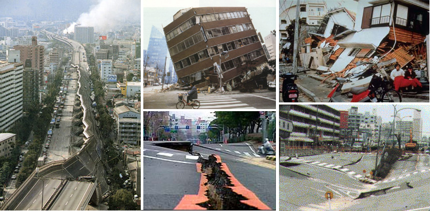
A major earthquake that hit Kobe on January 17, 1995 was 9.5 and resulted in damages to 150,000 buildings, damages worth $200 billion and deaths to over 6,000 people, injuries to 30,000 people and that left 300,000 homeless. Despite the exercises and drills, are we ready for this possible disaster.
Have we earthquake proofed our buildings, our bridges, our fly overs, or skyways.
NIST publications - Kobe earthquake
Abstract
The January 17, 1995 Hyogoken-Nanbu earthquake of magnitude 7.2 in JMA scale (Mw = 6.9), which struck Kobe, Japan and its surrounding area was the most severe earthquake to affect that region this century. The earthquake resulted in more than 6,000 deaths and over 30,000 injuries. Fires following the earthquake incinerated the equivalent of 70 U.S. city blocks. They together destroyed over 150,000 buildings and left about 300,000 people homeless. The economic loss as a result of this earthquake is estimated to reach $200 billion. An investigation was conducted under the auspices of the Panel on Wind and Seismic Effects of the U.S.-Japan Program in Natural Resources to observe, document, and summarize important lessons from this earthquake that can be used to mitigate the potentially tragic impact of future earthquakes on modern urbanized communities. An 18-member team was in Japan from February 12 to February 18, 1995 to study seismology, geology, and geotechnical effects; as well as the performance of buildings, lifelines, and fire safety systems. This document summarizes the information collected during as well as following this investigation. Key findings of the investigation include needs for research and for improvements in practices to achieve earthquake loss reduction in the United States.
What could be the possible damage to MM in case the West Valley fault moves? It would be tragic and a disaster of massive proportion. God help us
Here is the prediction:
According Johnny Yu, Manila Disaster Risk Reduction and Management (DRRM) officer-in-charge, the first scenario, to be conducted in the morning, will include an earthquake, a fire, and road traffic accidents involving hazardous materials.
“Based on our own hazard mapping, if the 7.2-magnitude earthquake strikes, Manila will experience an intensity 8 earthquake,” Yu said.
Yu added that an intensity 8 earthquake in Manila meant 300,000 possible collapsed structures and 500,000 casualties, including dead, missing, and injured residents. “This was from 2000 to 2004. It’s 2014 now so we’re expecting twice or thrice the damage."
There was a Magnitude 7.6 earthquake that rocked the Phil in 1992. The major earthquakes occur in this region of Phil Trench. It has been eerrily silent for the last 400 years and there are two possibilities: that the faults are sliding smoothly, and/or that pressure is building up and that may snap any time soon
The 7.6 quake happened at a fault within the Philippine Sea Plate, which is subducting beneath the Philippine Microplate. Some of the unusual aftershocks were so called "intraplate" ruptures, like the original quake, but happened at a shallower depth. And others of the unusual aftershocks were located west of the epicenter, within the Philippine Trench itself, where the plate is subducting. These are called interplate aftershocks because they happen at the boundary between two plates.
That segment of the trench hasn't seen a major earthquake in at least 400 years, but the shocks may be a sign that the plate boundary is linked to the intraplate rupture and that it is building up strain in preparation for a big one. No one will know until GPS equipment is installed and scientists collect more data, Lay said.
Eerily quiet


